


Everest Base camp Trekking Costing Trekking Price , about hotel , About food, Accommodations, about telephone, Internet, about good cafe, Book shop, museum , monastery
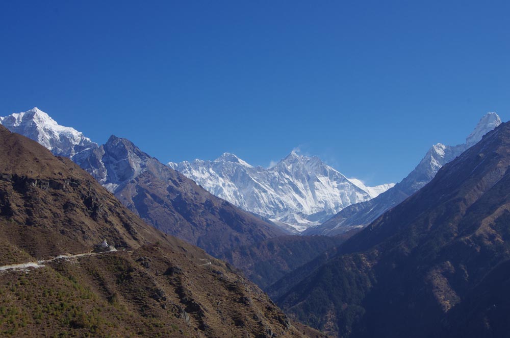
A view of Mount Everestbase camp
Everest Base Camp Trek is a famous challenging trek in Khumbu, Nepal.
Famous for its spectacular mountain peaks and the loyalty and friendliness of its inhabitants (the Sherpa s), the Everest region (Khumbu) is one of the most popular destinations for tourists in Nepal. While many of the routes through the mountains are arduous, there are ample places to rest and enjoy a meal along the way. Furthermore, don't worry about getting lost. Just ask a local the way to the next village on your route, and they will direct you. Most Sherpa s under the age of fifty can at least understand basic English, and many speak it fluently.
While trekking is possible in this area the whole year round, the best times to visit are from the beginning of March to mid May and from the beginning of September to mid November. The winters are very cold and snow may make it difficult to travel higher than Tengboche, and also lodges may be closed above this altitude. Summers, on the other hand, are wet, and the spectacular peaks are often lost in the clouds. April and early May is a good time to see the hedgerows and trees bursting into bloom, with Rhododendrons, in particular, adding a spectacular splash of colour to the landscape. However, dust from the plains of India during the spring routinely provide less than ideal conditions for clear mountain views. The views are much better after the summer monsoons have cleared the atmosphere of dust, but the days are shorter and cooler.
Trekkers' Information Management System (TIMS) is compulsory to visit Khumbu region, this was until 2010 issued free of charge but now costs 20USD or equivalent in Nepalese Rupees.
Lodges and restaurants in Khumbu only accept Nepalese rupees. Budget 2500 Rs per person per day for food and accommodation - prices rise with the altitude, though you may spend more in Namche because there is more on offer.
Prices are as follows: Lodges, basic room 300-700Rs Water 120-450Rs Coke 200-400Rs Meals 500-900Rs Hot Shower 200-500 Rs Candy 80-280Rs Battery Charging 100-300Rs per hour.
Prepare
In addition to obvious items such as hiking boots, warm clothing, UV sunblock etc., here is list of things that you might not have considered taking along, but that can greatly enhance the quality and comfort of your journey.
Water Disinfection drops. A 60ml bottle can be found in Kathmandu for around 10-30 Rs. This will let you treat your own water, saving you from buying new bottles. 1L of water at Namche is 100 Rs, past Namche its anywhere from 200-350 Rs.
A variety of clothing is necessary for the Mt Everest Base Camp trek. The emphasis on equipment necessary follows two simple aspects: Lightweight and Functional. The items you choose to take should be lightweight, dependable, and adaptable to a variety of extreme weather conditions. The quality of the trekking equipment you choose has a lot to do with how warm, dry, and safe you will remain> For this reason you have to be critical of quality and the proper fit of clothing.
You will need clothing for around Kathmandu, trekking in the humidity and heat, and to protect you from the cooler temperatures in the mountains.
A good pair of hiking boots (well broken in) - You will be spending five to six hours a day on the trail. Your boots are an important part of your gear. The boots can be light to medium, high or low. If you plan to go in the months when snow can fall, the high boots are better for hiking in the snow.
Soft and light shoes (sneakers or kung-fu shoes are perfect) - after a long hike in inflexible hiking boots, you will be extremely happy to have some light and soft footwear to to wear around the lodge or in the village.
Lightweight knapsack - this is very useful for short trips away from your lodge, and will save you having to lug your large backpack along. It should be big enough for your camera and a change of clothes and sleeping bag, if you plan to spend a night away.
Lightweight sleeping bag - as most (all?) lodges can offer you blankets, a light sleeping bag should be sufficient for the journey. Taking a light bag will save you valuable space in your backpack. But blankets often smell terrible, so the better alternative is a high quality down-sleeping bag (comfort-temperature at least -10 C°) with small packing volume to avoid spending nights fully dressed.
Fabric bandaids - blisters on the feet can turn a wonderful walk into a hell. Bandaids (sticking plasters) should be immediately applied to any area of the foot that there is irritation and friction - don't wait for the blister to develop before doing this. However, only fabric made band-aids (e.g., Moleskin) will stick to a sweaty foot. Others (even those that claim to be water-proof) will fall off in minutes. A good alternative to bandaids is duct tape. Works great for blisters and also proves invaluable in many other ways.
Binoculars -certainly not a necessity but they bring the mountains details closer and also great for spotting elusive wildlife.
Weather
You'll find up to date weather forecast at: The Weather Network
Guides/porters
Do you need a guide and porter for the journey? If you are strong, then a porter is not required, though hiring one does direct well needed cash into the homes of poor families and allows you more flexibility. If you do hire a porter, remember to keep valuables with you. The vast majority of porters are extremely honest, but it only takes one who is not to ruin a vacation! Expect to pay around 1200-1600 Rs (more if your load is very heavy) a day for a porter's services, and as far as Namche you are not expected to pay for accommodation and meals. However, due to the high price of food and lack of provisions for porters above Namche, meals should be provided. (NB: Namche has a cheap and clean lodge specially for porters). Anyway, ensure that your terms are clear at the time of hiring. This will save trouble later.
Guides are definitely not necessary if you are traveling no higher that Tengboche or Pangboche. Above that, you might consider hiring one. Not only can they guide you on the right path and explain local sights, but can be invaluable should you fall ill. Guides speak English (and often other languages - specify your choice when hiring) and need an official license to operate. They command a much higher rate than porters (negotiate), and carrying your bags is not part of their service. Like porters, they will find their own accommodation and meals unless you invite them.
In general, guides are local Sherpas or Tamangs and are usually named Lama; porters are Rai or belong to ethnic groups from other areas.
Guides and porters can be hired for a fee through trekking agencies in Kathmandu or you can inquire at lodges in Lukla or Namche. At Lukla airport, there are always hopeful porters milling around the exit, but it is better to use a lodge owner as an intermediary. They can help you negotiate a good deal and translate your specific needs. Eco Paradise, Lukla or Namche Hotel, Namche are convenient and good places to do this.
Get in
Fly to Lukla Airport from Kathmandu. There are several Airlines operating dozens of flights everyday. Among them Tara Air and Agni Air are generally considered the most reliable company plying the route. Sita Air also operates two flights every morning from Kathmandu Domestic Airport to Lukla at 7AM and 8:20AM. The flight takes around 25 minutes. During the summer rainy season, there may be substantial delays of flights, even a wait of one week is not unheard of. For the return journey, the flights leave Lukla at 7:40AM and 9AM. Helicopter Charter service is also available on demand and mostly used for rescue operation.
Alternatives are to fly to Phaplu airport, 2-3 trekking days south of Lukla, or to walk in from Jiri, which is 5-7 trekking days west of Lukla. These alternatives take more time and therefore are less popular, but are very peaceful and pleasant - and much safer than flying into Lukla.
Just after the village of Monju, there is check point for entering the Sagarmatha National Park. You will need to show your passport and pay a 3,000 Rs entry fee.
[edit] Get around
On foot. There are no roads in the Khumbu region.
Walk
Khumbu is an area for trekking. The trek can be as short as a two day walk from Lukla to Namche Bazaar or an eight to ten day trip to Everest Base Camp. Irrespective of the length of the journey, as there are no roads in the area, it will definitely involve putting on hiking boots and walking the mountain paths. Below is an itinerary from Lukla Airport to Everest Base Camp and all points in between.
Day one - Lukla airport (about US$115 from KTM) to Monju (2800m): Pass directly through the village of Lukla (there is no compelling reason to stop here, though it is a good place to have breakfast/lunch.) and follow the path to Namche. There will no doubt be a string of porters carrying goods up to the Sherpa capital, so the route is easy to locate. The first village after Lukla is Chheplung, and further down the trail, you will pass through Ghat and Phakding. Both these villages have a good selection of lodges and restaurants and are conveniently located for taking a meal break. However, if you still have enough stamina, it is advisable to press on to Monju (about 90 minutes to two hours from Phakding) to spend the night as this will give you a good start for the steep ascent to Namche the following morning. Lukla to Monju 6 miles and 6.5 hours.
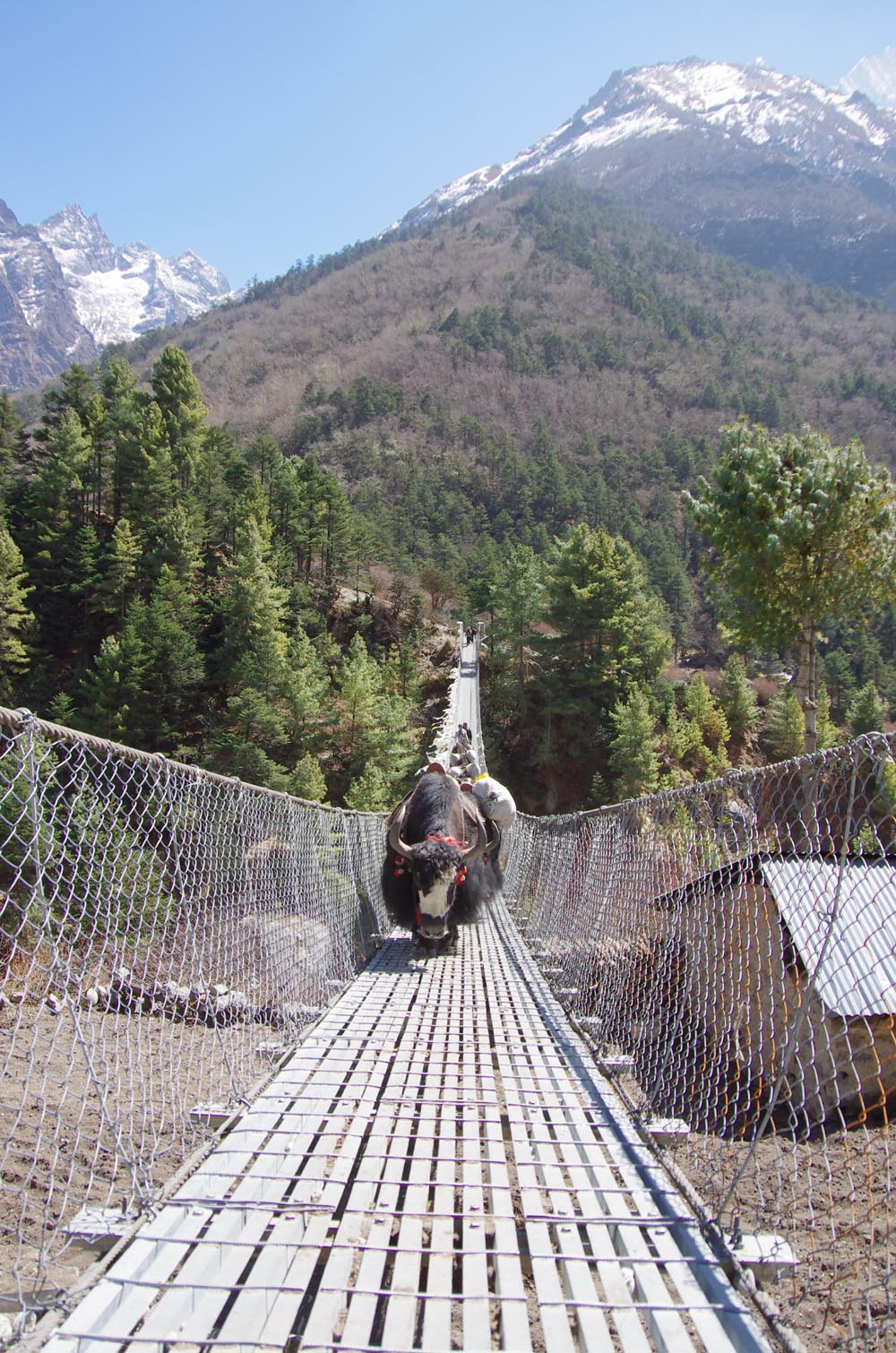
Day two - Monju to Namche: After passing through the Sagarmatha Park entrance (3,000rs for overseas visitors), the trail passes through the village of Jorsale and then along the river. You will cross two bridges before beginning the steep ascent to Namche, which can take up to three hours to complete. Be aware that there are no tea houses or lodges on this path, so ensure that you have ample water to get you to the top. In addition, you are now heading into a high altitude area, so take it easy. Even the fittest people are prone to altitude sickness. Monju to Namche 3 miles and 3 to 4 hours, almost all uphill.
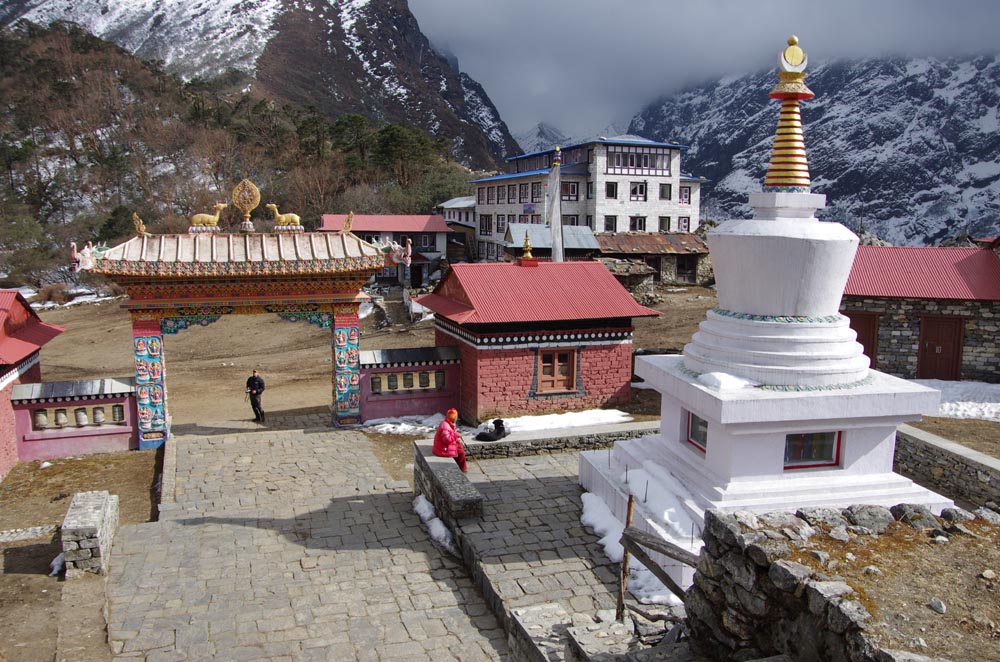
Days three and four - Namche Bazaar (3440m): It is recommended to take an altitude acclimatization rest day in Namche. Although no more than a village, the Sherpa capital has two museums, several internet cafes, and, at last count, two pizza houses and three cafes (locally known as bakeries), so there is much to keep you occupied during your stay here. Namche also has two official money changers, so it is a good place to stock up on local currency for the days ahead (NB: Lodges and restaurants in Khumbu only accept Nepali Rupees). There is also a reasonable selection of English books, though the prices are higher than in Kathmandu.
During your acclimatization rest day, you might like to visit neighboring villages. Khumjung (3790m) is over the hill directly behind Namche, and takes about one and a half to two hours to reach. There are several sights in the village (See listings below) and a few lodges and eateries. Khunde is a short walk from Khumjung. Getting there: Take the Tengboche trail, then at the top of the hill above Namche, near the huge mani stone and just past the bank, head straight up the mountain - the wider path to the right goes to Tengboche. After a steep climb, you will arrive at an airstrip. Cross this and rejoin the path at the other side. After a short distance you'll pass a stupa. From there, take the paved path down the hill. Soon you will see the playground and school buildings of Khumjung Hillary School. Thame (3750m) is a more traditional village that is about a two and a half hour to three hour walk from Namche. Getting there: Leave Namche on the path that passes the ochre coloured Namche Monastery (Namche Gompa). From here, it is a relatively flat walk that takes in some very pleasant scenery. The first hamlet on the route is 'Phurte,' identified by the forest nursery, and then 'Tesho.' The water that runs through 'Tesho' comes directly from 'Mount Khumbi Yui Lha' - the most sacred mountain to the Sherpas - so there are several retreat huts built into the niches here. Thame is the next village on the trail, and a good place to take lunch. Thame has a few lodges and is home to one of Khumbu's oldest monasteries. This trail is also the traditional route to Tibet, so don't be surprised to encounter caravans of yaks led by long-haired Tibetan merchants on your walk.
Day five - Namche to Tengboche (3870m/12696ft): After a short but steep climb out of Namche Bazaar, then walk on a fairly level trail to the villages of Kenjuma and Sanasa. Here there are extensive displays of souvenirs to tempt you and food and drinks. The Ama Dablam Lodge in Kanjuma has some good food and the sitting area out front offers uninhibited views of Ama Dablam. In addition, the lodge reputedly has the best selection of jewellery for sale in the whole of Khumbu, so if you don't plan to return this way, pick out a few light souvenirs - they will forever remind you of this sun-blessed place and the sparkling snow capped peak of Ama Dablam. After a short while, the trail descends to the level of the Dudh Koshi River, and you will pass a few hamlets and cross several bridges. Then at the hamlet of Phunki Thanga (marked by its water driven prayer wheels), the trail ascends steeply. There are no tea houses or lodges on this stretch, so take some refreshment in Phunki Thanga and stock up on water for the one and a half to two hour climb to Tengboche. NB: Take it easy going up here. The air is thinner than you are aware! You want to avoid mountain sickness.
Day six: For those heading for Everest, the trail passes through the villages of Deboche (here, there is a small nunnery on the left - definitely worth a visit), Pangboche (3860m/12664ft), Dingboche and finally Periche (4240m/13910ft). All these villages offer food and lodgings. Pangboche (especially Upper-Pangboche, where the local monastery is located) is, however, probably the the most pleasant as it is surrounded by trees. So, if you decide to take the journey slowly, this is the best place to rest and relax. For those heading for Island Peak Trek and/or the Lhotse Glacier, your final destination will be Chukhung. As this is further than Periche, you will definitely need to stop the night in Pangboche or Dingboche.
Day seven: In Periche, you will need to take a day to acclimatize to the high altitude. Take short, slow walks around the village, marvel at the peaks and dig out the book you bought in Namche, but whatever you do, don't push it at this point. If you begin to feel unwell, inform your guide or lodge owner and return as quickly as possible to a lower altitude. The experts say hike high sleep low. So some Nepal experts recommend that if you are feeling well, to hike each day to a higher elevation than you will sleep.
Day eight - Periche to Lobuche (4930m/16174ft): Spend the night in this small village packed with tourists. There are several lodges at this village but not much to do here besides eat and sleep. Often trekkers entering Lobuche will find the lodges full and may have to share a room with a stranger or sleep in the common room. Even if you have a room, you may be asked by the lodge owner to share it with someone.
Day nine - Lobuche to Gorak Shep (5160m/16929ft): This is a fairly easy hike and should take about 3 hours. You can take a short side-trip and visit the Everest Pyramid, a weather station built by Italians. In Gorak Shep threr is a small, usually frozen lake. This village now has three lodges: Himalaya Lodge, Snowland Lodge and the Kala Pattar lodge. Gorak Shep will be your base to visit the Everest Base Camp (5380m/17650ft) and to climb the hill behind the lodges called Kala Patthar (5643m/18513ft) with great views of Mt. Everest and surrounding mountains.
Alternate Return Trip: From Lobuche, the trail via Cho La (5370m) to the wonderful Gokyo valley with its glacier lakes and fine views offers some stunning scenery and is not as crowded as that to Everest.
Mount Everest
Mount Everest is the highest mountain in the world. Its height is 8,848 metres (29,028 ft). Its alternate names are Qomolangma, Sagarmatha, and Chomolungma. Mount Everest lies on the border of Nepal and China, with about half of the mountain lying on each side of the border. Sir Edmund Hillary and Tenzing Norgay first climbed it in 1953, with Hillary taking the famous photograph of Tenzing Norgay in the summit.
There are several bodies still lying on the upper portions of the mountain above the South Col on the Nepal side and the North East ridge on the Tibetan side. The Governments of Nepal and China requires all prospective climbers to purchase a permit. The fees depend on the route and season of the climb. A standard Nepali permit is $USD 50,000 for 7 climbers. There are also additional bonds to ensure garbage is removed from the mountain.
There are two main routes, Southeast and Northeast, for climbing Mt. Everest. Southeast is the most frequently-used route because it is generally considered safer and has easier access. The ascent via the southeast ridge begins with a trek to Base Camp at 5,380 m (17,600 ft) on the south side of Everest in Nepal. Expedition members usually fly into Lukla (2,860 m) from Kathmandu and pass through Namche Bazaar. Climbers then hike to Base Camp, which usually takes six to eight days, allowing for proper altitude acclimatization in order to prevent altitude sickness. Climbing equipment and supplies are carried by yaks, dzopkyos (yak hybrids) and human porters to Base Camp on the Khumbu Glacier. When Hillary and Tenzing climbed Everest in 1953, they started from Kathmandu Valley, as there were no roads further east at that time.
Everest base Camp
At Everest Base Camp, climbers will often spend 4 - 8 weeks, acclimatizing to the altitude. During that time, the "Icefall Doctors" will set up ropes and ladders in the notoriously unstable Khumbu Icefall. Seracs, crevasses and shifting blocks of ice make the icefall one of the most dangerous sections of the route. Many climbers and Sherpas have been killed in this section. To reduce the risk, climbers will usually begin their ascent well before sunrise when the freezing temperatures glue ice blocks in place. Above the icefall is Camp I at 6,065 m (19,900 ft) Camp 1 is mostly a temporary camp with most climbers just spending one night at this camp.
Camp II
Base Camp II, Advanced Base Camp (ABC) is established at 6,400 m (21,300 ft). The Western Cwm is a relatively flat, gently rising glacial valley, marked by huge lateral crevasses in the centre which prevent direct access to the upper reaches of the Cwm. Climbers are forced to cross on the far right near the base of Nuptse to a small passageway known as the "Nuptse corner". The Western Cwm as the topography of the area geneally cuts off wind from the climbing route. The high altitude and a clear, windless day can make the Western Cwm unbearably hot for climbers.
Camp III
From ABC, climbers ascend the Lhotse face on set ropes up to Camp III, situated on small ledges at approximately 7,200 m to 7,400 m. From there, it is another 500 metres to Camp IV on the South Col at 7,920 m (26,000 ft). From Camp III to Camp IV, mountaineers are faced with two additional obstacles: The “Geneva Spur” and The “Yellow Band”. The Geneva Spur is an anvil shaped rib of black rock named by a 1952 Swiss expedition. Fixed ropes help climbers in scrambling over this snow covered rock band. The Yellow Band is a section of sedimentary sandstone. The route from the base of the Lhotse face to the Summit is almost always completely fixed with static line.
On the South Col, climbers are very close to 8,000 m and can only spend limited time at those altitudes even with supplemental oxygen. Climbers typically only have a maximum of two or three days they can tolerate at this altitude for making peak bids. Clear weather and low winds are important factors when deciding on a summit attempt. If weather does not cooperate within these short few days, climbers are forced to move down, many all the way back down to Base Camp.
Camp IV
From Camp IV, mountaineers will start their summit push from 8 pm to 2 am with the hope of reaching the summit (still another 1,000 metres above) within 10 to 12 hours. Climbers will first reach "The Balcony" at 8,400 m (27,700 ft), a small platform where they can rest and gaze at peaks to the south and east in the early dawn light. Continuing up the ridge, climbers are then faced with a series of impressive rock steps which usually forces them to the east into waist deep snow, a grave sudden large amount hazard. At 8,750 m (28,700 ft), a small table-sized arena of ice and snow marks the South Summit.
From the South Peak, mountaineers go after the knife-edge southeast ridge along which is known as the "Cornice traverse" where snow griping to irregular rock. This is the most bare part of the climb as a misstep to the left would send one 2,400 m (8,000 ft) down the southwest face while to the immediate right is the 3,050 m (10,000 ft) Kangshung face. At the end of this traverse is an imposing 12 m (40 ft) rock wall called the "Hillary Step" at 8,760 m (28,750 ft).
Tenzing and Hillary were the first mountaineers to rise this step and they did it with prehistoric ice climbing equipment and without fixed ropes. Now, climbers will ascend this step using fixed ropes previously set up by Sherpas. Once above the step, it is a comparatively easy climb to the top on fairly angled snow slopes - though the exposure on the ridge is extreme especially while traversing very large cornices of snow. After the Hillary Step, climbers also must traverse a very loose and rocky section that has a very large entanglement of fixed ropes that can be troublesome in bad weather. Climbers will typically spend less than a half-hour on "top of the world" as they realize the need to descend to Camp IV before darkness sets in, afternoon weather becomes a serious problem, or supplemental oxygen tanks run out.
[edit] Stay safe
Khumbu is a very safe region and violent crime is almost unheard of. However, due to the amount of people flowing through the area on treks, it is advisable to always keep your valuables in sight.
Altitude sickness affects even young and healthy people and is a genuine problem in Khumbu. If you feel dizzy, suffer palpitations or severe headaches, return immediately to lower altitude. Do not take altitude sickness lightly. It can and does kill!
Yaks may be photogenic, but they are aggressive and unpredictable. Always stand on the upper slope (i.e., above the path, away from the drop-off) to let yaks pass. Every Sherpa has a tale about Westerners who have stood on the lower side of a trail to let a herd of yaks pass and been killed after being pushed off.
Don't drink the water no matter how pristine it appears. Use iodine tablets as a purifier or purchase boiled water. Exceptions: Namche and Phortse have clean water supplies that the locals drink directly from the faucet. However, this may not be a good idea for outsiders lacking immunity to local bacteria, but certainly it should be ok for brushing teeth.
There is an emergency rescue centre based in Namgyal’s lodge in the village of Machhermo in the Gokyo Valley manned by two volunteer doctors. Note: This is purely an emergency rescue centre, and the doctors will not treat common ailments.
Stay healthy
Clinics are a sparse resource in Khumbu. However, should you require medical attention there are two possibilities:
Western medicine - Kunde Clinic, in Kunde Village (above Namche) has Western trained doctors and is a surprisingly well equipped facility - they even have a decompression chamber for those suffering with severe altitude sickness. On your return journey, you might like to donate your unused medicines to Kunde Clinic, though ensure that they are clearly labeled in English - even the most valuable medicine is useless if there are no instructions on how to use it.
The Himalayan Rescue Association operates a clinic staffed by western physicians in Pheriche. They give a daily lecture on taking care of your health in the Khumbu region, and, for Rs. 100, check your blood oxygen content and pulse rate. This is a good place to stop at even if you are not experiencing any health problems. Check out their t-shirts, scarfs and hats, the proceeds of which go towards operating the clinic.
Tibetan medicine - the Healing Centre in Namche offers treatments using natural formulas. It is located next to the Camp de Base hotel, but entered from the path in front of the library. This clinic provides free treatment for porters and other patients on low income. In order to continue this service, donations are greatly appreciated.
Along the trail, you will also see small medical stations. These stations generally have very rudimentary facilities and can only realistically offer treatment for very minor ailments, such as cuts and bruises and (non-altitude sickness related) headaches etc.
Namche also has a dental clinic, located on the right side slope of the village when looking up.
Contact
There are currently no telephone lines or mailing addresses in the Everest region.
Namche has a post office, but there are mixed reports of letters reaching their destinations. Postage stamps are also available in local shops.
International phone calls can be made in Namche and many of the other villages in the region, however this is very expensive compared to Kathmandu. The cheapest place is the one-phone government telephone office, on the second floor of the nondescript wooden building behind Hotel Buddha, identified with an official yellow sign in Nepalese with a faded paper sign in English stuck on to it. Expect a lengthy queue on Saturdays (market day).
Namche also has several Internet cafes. A good one with well working keyboards and Photoshop is Namche Cyber Cafe next to Everest Bakery. They also have Wi-Fi. 100rs per half hour, 200 an hour.
Tengboche has a internet cafe, its 20 rs per min.
Dingboche as a fast satellite internet laptops at 20 rs per min. Its called Peak 38th.
Gorak Shep internet cafe is 25rs per min, and is very slow.
Nepal Trekking guides and Tour Leader
http://www.nepalguideinfo.com
Email-:sanjib-adhikari@hotmail.com
Mobile+9779841613822
P.O.B0x=4453 KATHMANDU Nepal